The Ottawa River runs wide and steady past the limestone cliffs of Parliament Hill, its surface carrying the faint metallic scent of spring runoff from the Shield country to the north. On clear afternoons the current pulls small ice floes toward the Chaudière Falls, while gulls wheel above the water and the low throb of outboard motors drifts from the Quebec side. Across the river the forested ridges of Gatineau Park rise in a single dark line, still holding patches of snow in the shaded hollows even as the city streets below begin to dry.
Visitors who cross the Champlain Bridge in April enter a different season. The park’s 361 square kilometres of rolling Canadian Shield terrain open gradually, with trails that remain firm underfoot once the frost leaves the ground. Daily temperatures at the visitor centre near Old Chelsea average between 8 °C and 14 °C, and the first migrant warblers appear along the edges of open fields by the third week of the month.
Spring in the park
Maple trees along the park’s western boundary are tapped in late March, and the resulting syrup is boiled in small sugar shacks that operate on weekends through the first half of April. Visitors can watch the process at the Sugarbush Trail near the Mackenzie King Estate, where steam rises from evaporators between 10 a.m. and 4 p.m. on operating days. The same trail continues for 2.8 kilometres through mixed hardwood stands, crossing two wooden bridges over small streams that run high with meltwater until early May.
Hiking routes that remain accessible once the ground firms include the 5.2-kilometre Pink Lake loop and the 7.8-kilometre King Mountain trail. Both begin at the parking area off Gatineau Parkway, which opens to private vehicles on the first Saturday in April. Snow lingers longest on the north-facing slopes, so hikers should carry micro-spikes until mid-month. Bird activity increases steadily through spring, with warblers, ovenbirds, and other migrants arriving in the park’s mixed hardwood stands as the month progresses.
Cycling on the parkway itself becomes practical once the gates are removed, usually around 15 April. The 14-kilometre stretch between the Champlain Lookout and Lac Philippe offers a steady climb of 180 metres and is closed to motor traffic until late May. Surface temperatures on the asphalt reach 18 °C by mid-afternoon on clear days, while shaded sections remain several degrees cooler.
The park’s Chelsea visitor centre posts updated trail conditions each morning; check the official Gatineau Park website or call ahead for the current schedule. Staff post notices about black bear activity, which rises as soon as the first patches of bare ground appear near the lakes. Rangers recommend storing food in vehicle trunks and maintaining a distance of at least 30 metres from any animal observed.
For those planning a longer stay, the Best time to visit Ottawa page outlines average precipitation and daylight hours for the surrounding region through the remainder of the year.
| Season | Signature activity | Key trail or spot |
|---|---|---|
| Spring | Maple sugaring, birdwatching | Sugarbush Trail (2.8 km) |
| Summer | Swimming, canoeing | Meech Lake, Lac Philippe |
| Autumn | Foliage viewing | Champlain Lookout (peak late Sept-early Oct) |
| Winter | Cross-country skiing, snowshoeing | 150 km groomed network |
Summer at the lakes
By the first week of July the park’s larger lakes reach comfortable swimming temperatures. Meech Lake’s public beach near the south end draws steady summer crowds, with water conditions that vary through the season — check current advisories on the official site before heading out. The beach generally operates daily between Victoria Day and Labour Day, with lifeguards on duty during posted hours. Parking fills quickly on Saturdays and Sundays, so an early arrival or a backup plan is worth considering.
Lac Philippe, located north of Meech Lake, offers supervised beaches and a boat-launch ramp. Canoe and kayak rentals are available at the concession near the dam. Afternoon winds can create small whitecaps later in the day, so paddlers should plan accordingly. Motorboats are restricted to low horsepower, and a no-wake zone applies near shore.
Overnight camping is available across several campgrounds around Lac Philippe and other park sectors. Reservations open through the National Capital Commission’s official booking website each year; check the site directly for the current opening date, as it can shift from year to year. Each site includes a picnic table and fire ring, and firewood is typically sold at the entrance kiosks — confirm hours and pricing on site. Quiet hours are enforced by park wardens on bicycle patrol.
The 10.4-kilometre trail around Lac Philippe provides a shaded walk under a canopy of sugar maple and yellow birch. Elevation gain is minimal, yet the path crosses several small wetlands where dragonflies are abundant in July. Early morning visits, before 8 a.m., reduce encounters with biting insects that become active once temperatures exceed 22 °C.
Further information on regional travel patterns is available at voyage-canada.com.
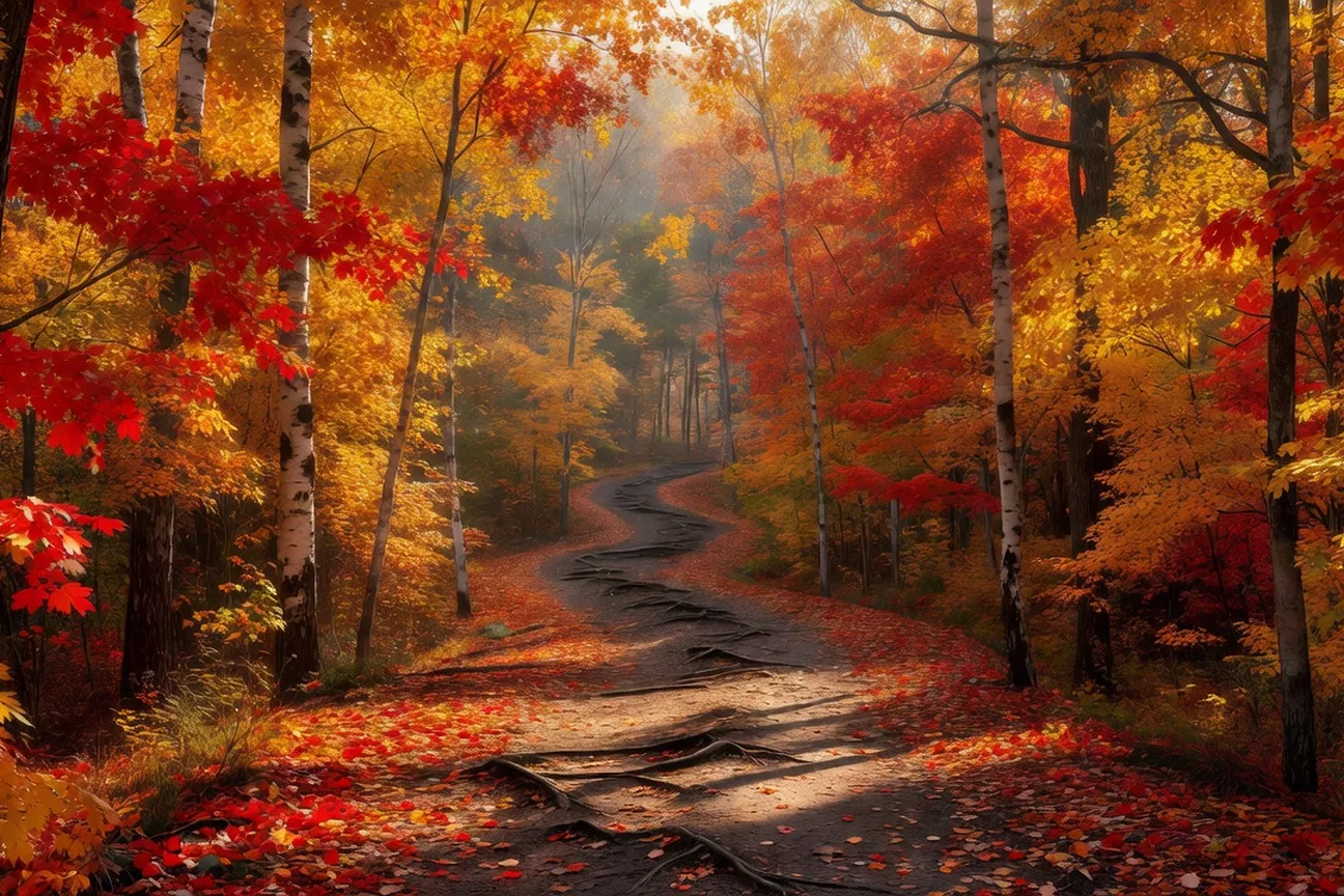
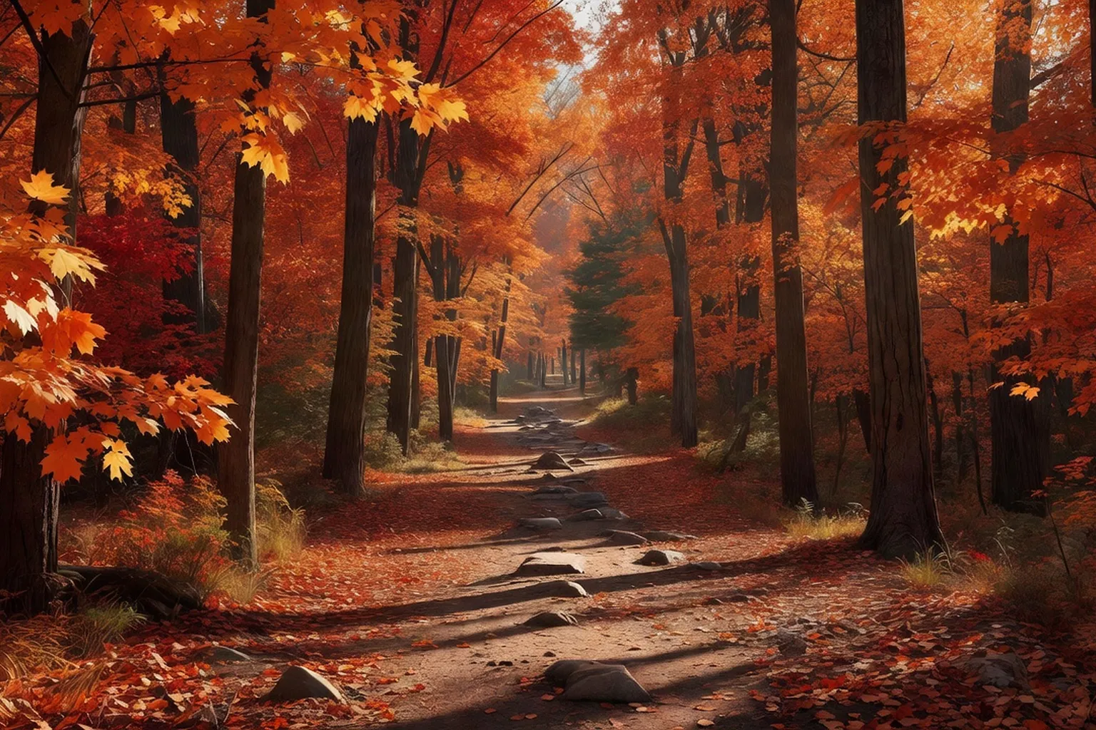
Autumn foliage
Colour change in the park begins at the highest elevations first and gradually works its way down toward the river, so a visit timed for late September through early October generally offers the best odds of seeing strong colour at the Champlain Lookout — though the exact peak shifts from year to year with weather. The lookout platform remains open daily into autumn, with vehicle access permitted until the first significant snowfall.
The 2.1-kilometre trail to the top of Mont King offers an alternative viewpoint with fewer visitors on weekdays. The path gains 145 metres over a series of switchbacks and is surfaced with crushed stone that remains firm after light rain. Parking at the trailhead is limited to 35 spaces; overflow occurs after 10 a.m. on Saturdays.
Fewer black bears remain active once berries are depleted, though sightings still occur near the park’s western boundary until mid-October. Rangers continue to post advisories at all trailheads. The visitor centre reduces its hours to 9 a.m.–4 p.m. after Thanksgiving and closes entirely on 31 October.
Road cycling remains possible on the Gatineau Parkway until the gates are reinstalled, usually in the third week of October. Morning temperatures at that time average 4 °C, rising to 11 °C by early afternoon, so riders are advised to carry an extra layer. The 22-kilometre loop from Old Chelsea to the Luskville Falls viewpoint provides consistent elevation changes and is largely free of motor traffic once the seasonal closure begins.
For travellers combining a park visit with other regional excursions, the Day trips section lists additional routes that remain practical through late autumn.
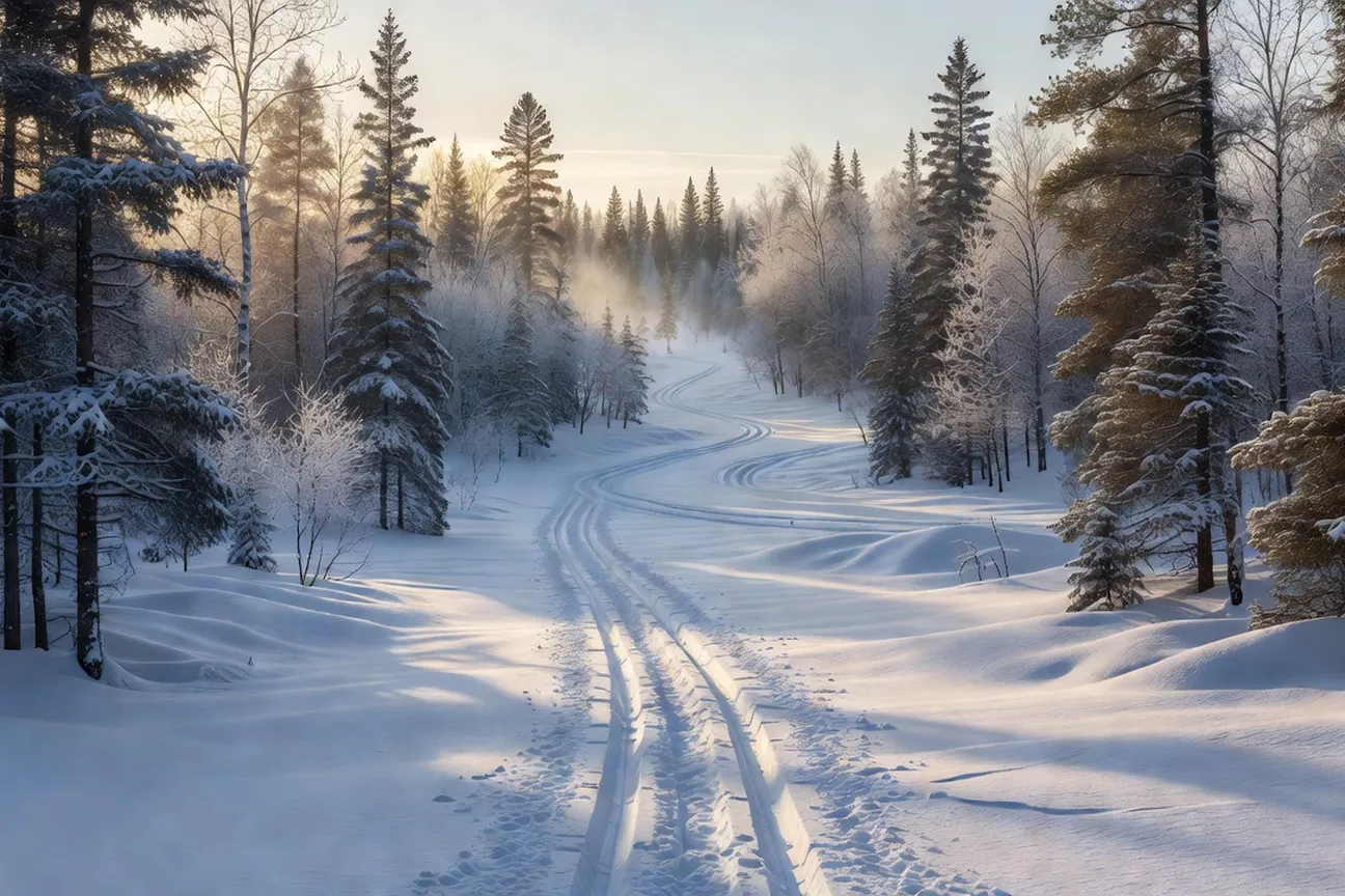
Winter cross-country skiing
Gatineau Park maintains approximately 150 kilometres of groomed cross-country ski trails through the winter months. Snow cover is typically reliable from mid-December to late March, with trail conditions updated daily by park staff. The network includes both classic and skate-skiing surfaces, and several loops remain lit until 22:00 on selected routes near the park’s southern edge.
Visitors reach the main ski centres by following Highway 5 north from Ottawa and exiting at the Gatineau Park signs. Parking at the P5 and P8 lots fills quickly on weekends; weekday mornings offer quieter access. Equipment rentals are available at Camp Fortune, where staff fit skis, boots, and poles for visitors. Day pass pricing varies by season and category — check current rates on the official site before your visit.
Trail surfaces vary with elevation. Lower loops near the lakes remain sheltered by mixed hardwood stands, while higher sections along the ridge expose skiers to steady winds and firmer snowpack. Average daytime temperatures in January hover around −10 °C, though wind chill can drop the perceived temperature another five to eight degrees. Skiers are advised to carry a map and check the park’s recorded trail line for closures caused by heavy overnight snowfall or wildlife activity.
The trail network draws large numbers of skiers each winter, from casual weekend visitors to competitive racers training on the groomed loops. Volunteers from the Friends of Gatineau Park assist with track-setting on secondary loops that receive less mechanical grooming. These quieter corridors pass through stands of eastern hemlock and occasional open wetlands where snowshoe hare tracks are commonly visible beside the ski tracks.
Mackenzie King Estate
The Mackenzie King Estate occupies a 231-hectare parcel within the southern section of Gatineau Park. The site preserves the summer residence of William Lyon Mackenzie King, Canada’s tenth prime minister, who acquired the property in 1903 and expanded it until his death in 1950. Stone foundations of the main residence, known as Kingswood, remain visible, along with several smaller cottages and a collection of garden structures.
The estate grounds stay open daily throughout winter, although interior rooms of the cottages are closed from November to April. Visitors follow a 2.4-kilometre interpretive loop that begins at the Kingsmere parking area. The path is packed but not groomed for skiing, so most people walk or snowshoe. interpretive panels along the route note the dates of construction for each building and the origin of the stone statuary that King collected during his travels.
In winter the formal gardens are reduced to geometric outlines beneath snow. The stone walls and pergolas remain prominent, and the absence of foliage makes the alignment of sightlines toward Kingsmere Lake more apparent. Guided walks are sometimes offered by park interpreters during the season — check the official Gatineau Park calendar for current dates, times, and registration details.
The estate also functions as a junction for several ski trails that continue northward into the larger park network. Skiers departing from the estate can connect to the 10-kilometre Lauriault loop or the shorter 4-kilometre Kingsmere Lake circuit without returning to a separate trailhead. Benches placed at regular intervals along the estate paths provide sheltered spots to rest and adjust layers.
The park’s winter quiet reveals the same contours of land and water that shaped Mackenzie King’s private landscape nearly a century ago.
Choosing your trail
Trail selection begins with an assessment of distance and elevation gain. The park’s visitor map, available at every entrance kiosk, lists each loop with its total length and difficulty rating. Beginners are directed to the 5-kilometre Pink Lake circuit, which follows a mostly level former logging road beside the lake. Intermediate skiers often choose the 12-kilometre Luskville Falls loop, where a steady climb of 180 metres leads to an open viewpoint before a long descent.
Advanced visitors tackle the 21-kilometre Ridge Road trail, which traverses the park’s highest plateau and requires steady navigation between widely spaced blue diamond markers. Avalanche risk remains negligible in Gatineau Park, yet sudden temperature shifts can create icy crust on north-facing slopes after midday thaw and refreeze. Checking the park website or calling the recorded trail line before departure reduces the chance of encountering unexpected surface conditions.
Daylight hours in January limit most outings to seven hours or fewer. Skiers planning longer routes are encouraged to start no later than 09:00. Some backcountry loops include emergency shelters for skiers caught out by weather or injury; their exact locations and facilities are marked on the official park trail map, which is worth reviewing before setting out on a longer route.
Before setting out on a longer loop, a short checklist:
- Confirm trail conditions on the park website or the recorded trail line
- Carry a map — cell coverage is limited in remote sections
- Pack water, snacks and a spare layer regardless of season
- Note the nearest emergency shelter location before starting
- Leave a printed route on the vehicle dashboard so wardens can locate overdue parties
Day trips from Ottawa typically allow four to five hours on the snow once travel and rental time are subtracted. Those seeking additional planning resources can consult verygreentrip.com for updated snow-depth reports and user photographs of current trail surfaces.
The choice of trail also affects parking duration, since lot closing times vary by location and season — posted signage at each lot gives the current hours. Leaving a printed copy of the planned route on the vehicle dashboard assists park wardens in locating overdue parties.
Two paragraphs close the account. Gatineau Park’s seasonal rhythms remain tied to Ottawa’s own civic calendar. Residents cross the Ottawa River on weekends to ski or walk, then return to the capital’s museums and parliamentary precincts the following weekday. The park therefore functions less as an escape than as a measured counterpart to the city’s built fabric, its trails offering a legible record of topography and season that complements the urban grid.
Visitors who allocate a full day to the park often conclude their Ottawa itinerary with a clearer sense of the region’s physical extent. The same river that divides Ontario from Quebec also links the parliamentary buildings to the forested hills visible from the Peace Tower, reminding travellers that the capital’s identity rests equally on its legislative core and on the accessible natural reserve immediately to its north.
Frequently asked
Gatineau Park lies directly across the Ottawa River in Quebec and is accessible by car via the Champlain, Alexandra, or Macdonald-Cartier bridges. OC Transpo bus routes connect to several trailheads, though a vehicle permit is still required for parking. Check current bridge and road conditions on the official site before departure.
Summer and fall feature hiking, cycling on designated paths, and swimming at Lac La Pêche and other beaches. Winter provides groomed trails for cross-country skiing, snowshoeing, and fat biking, with some routes lit for evening use. Spring offers quieter trails for birdwatching, though mud and seasonal closures should be expected.
A daily or annual vehicle access permit is needed for most parking areas and can be bought online or at select gates. Pedestrians and cyclists may enter fee-free on certain trails, but parking still requires a permit. Seasonal passes provide cost savings for repeated visits.
Stay on marked trails and carry a map or GPS device, as cell coverage can be limited in remote sections. Be alert for wildlife including black bears and moose, and pack water, snacks, and layered clothing for variable weather. Always review current trail conditions and any advisories on the park website before heading out.
Frontcountry campgrounds operate from spring through fall and require advance reservations through Parks Canada. Limited winter camping is offered at select backcountry sites with prior booking. Facilities and services vary by season, so confirm availability and regulations on the official booking portal.